


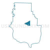
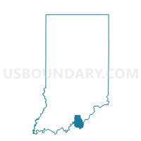
HARRISON EAST, Harrison County, Indiana
About
Outline

Summary
| Unique Area Identifier | 577629 |
| Name | HARRISON EAST |
| County | Harrison County |
| State | Indiana |
| Area (square miles) | 7.51 |
| Land Area (square miles) | 7.51 |
| Water Area (square miles) | 0.00 |
| % of Land Area | 100.00 |
| % of Water Area | 0.00 |
| Latitude of the Internal Point | 38.20750400 |
| Longtitude of the Internal Point | -86.07518030 |
Maps

Graphs
Select a template below for downloading or customizing gragh for HARRISON EAST, Harrison County, Indiana


Neighbors
Neighoring Voting District (by Name) Neighboring Voting District on the Map
- CORYDON EAST, Harrison County, IN
- FRANKLIN NORTH, Harrison County, IN
- FRANKLIN SOUTH, Harrison County, IN
- HARRISON NORTHEAST, Harrison County, IN
- HARRISON SOUTHEAST, Harrison County, IN
- WEBSTER EAST, Harrison County, IN
- WEBSTER WEST, Harrison County, IN
Top 10 Neighboring County Subdivision (by Population) Neighboring County Subdivision on the Map
- Harrison township, Harrison County, IN (12,484)
- Franklin township, Harrison County, IN (4,104)
- Webster township, Harrison County, IN (1,781)